My introduction to the lost world of the Burragorang Valley was through a talk given by Robyn Collier. Robyn Collier is an accomplished artist who has had an association with Burragorang for over 40 years. This in itself is unusual as the valley has formed part of the wider Warragamba Dam catchment area since 1946. It is a restricted access area and is not accessible to the public.
Burragorang had been a vibrant mountain community and a popular tourist holiday destination. It offered all the pleasures and outdoor activities of a country holiday within easy reach of Sydney. The valley, nestled near Camden where the Wollondilly, Nattai and Cox’s rivers meet, was home to the Gundungurra people for thousands of years. An Aboriginal legend associated with the creation of the valley is referenced on the Water NSW site:
A creation story of the Gundungurra people describes how Gurangatch, a large reptile-fish creature, shaped the landscape as he fought Mirragan, the tiger quoll. Evidence of the cross-country fight can still be seen in and around the Warragamba catchment.
Colonial settlers began to divide the land in the valley from 1826; the discovery of the valley is attributed to Ensign Barrallier in 1802 during an attempt to cross the Blue Mountains. It is linked with the cattle that went missing from the First Fleet settlement, finding good feed in the ‘Cow Pasture Plains’. A glimpse into the beauty of the area can be seen in a painting by JH Carse in 1879 – it also shows the steep, hairpin track that had to be crossed to gain access to the valley.

In 1845 the valley was identified as an ideal place for a dam by Polish explorer Count Paul Strzelecki, and in 1869 a recommendation to build a 50-metre high rock wall dam across the Warragamba River was made to the Water Supply of Sydney board. The engineering and economic challenges would take nearly a century to overcome.
It is hard to comprehend how the inhabitants of the valley and surrounding areas felt when it was announced in 1946 that the area would be cleared as part of the Warragamba Dam project to provide water for Sydney. People were moved out of the valley, receiving notional amounts for their lost properties and livelihood. Cemeteries were dug up and bodies relocated according to the wishes of relatives. Buildings were demolished or moved.
The history of this place is not forgotten. There is a link to an ABC news article here which marks the sixtieth anniversary of the flooding of the catchment in 2018. People who lived in the valley gather three times each year to reminisce about their life there. An idea of the beauty of the place can be glimpsed in old postcards, photos and paintings, such as Camp in Burragorang Valley by Rubery Bennett, which can be seen here.

A personal insight into the effect of the drowning of the valley is offered on this post titled ‘Warragamba Dam = death knell to Burragorang Valley’. The post features construction photos of the dam as well as photos of extended family camping holidays and provides some insight into what life in the valley would have been like.
This video on ABC Open called ‘A Drowned Valley’ features short interviews with some of the people who lived and loved the valley and is well worth a look. The comments include lots of fond reminiscing about this special place.

But how does this flooded valley link to Robyn Collier? In the early 1970s, Collier had the rare opportunity to spend some time in the Burragorang Valley. She completed a body of work which became a successful exhibition before heading off to discover other parts of the country and the world in general.
In 2014-2015, she began the process to gain access to the area as part of a final exhibition about the valley. This was carried out jointly with local historian and writer, Jim Smith. Being able to get to the valley involved bloody-minded persistence as the bureaucratic requirements were intense. Robyn noted the many changes over the decades as the scrub took over areas. There were some dwellings falling into states of disrepair whilst others were being maintained. There was a sadness, too, at this being the final visit to a much-loved place as access issues become impossible to overcome.
Robyn shared photos of the valley along with some of the changes documented in her artwork across the decades. Robyn features some of her paintings from the valley in her online gallery which can be found here. An overview of her long relationship with this unique location is provided in an article on Wild.
Robyn spoke of her fascination with ghost towns, and the irresistible tug of a place like the valley. It was interesting to see the contrast of some scenes, forty years apart. Some structures, such as a shearing shed with a wool sorting table, remain remarkably intact. Others have started to fold down upon themselves, tumbling back to the earth as nature takes back control.
This chance attendance of a talk by an artist on a place that I’d not heard of before sent me into a rabbit hole of reading as a lost valley began to take shape before my eyes.

Now there are plans afoot to raise the dam wall by 14 metres. This could potentially impact up to 1300 hectares of world heritage listed Blue Mountains bushland as well as destroying a number of Aboriginal cultural sites. The government justification behind it is to protect the 90,000 people and 12,000 homes that lie in the floodplains downstream near the Hawkesbury-Nepean rivers. There is resistance to this, including from the Give A Dam community group.
When was your last encounter with a lost place?
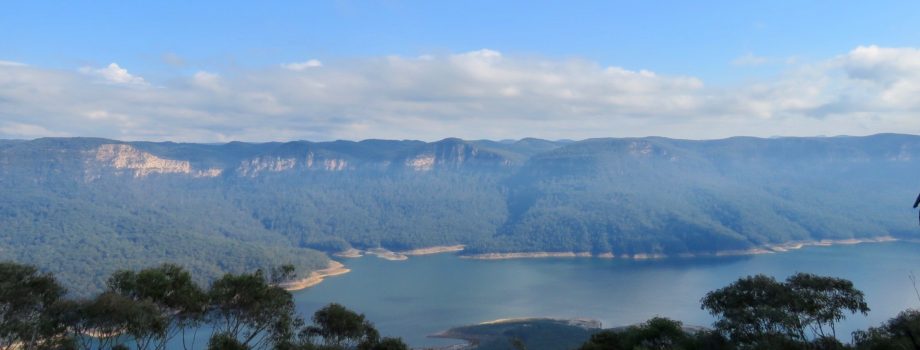
[Photo: Lake Burragorang – there had been hazard reduction burns through the catchment area, adding a layer of haze to the view]


Leave a comment